


Content uploaded by Philip Esper
Author content
All content in this area was uploaded by Philip Esper on Jun 26, 2014
Content may be subject to copyright.
1
British Geological / Geotechnical Society
BGS Special Publications, 1996
Keynote Paper in BGS Int’l Conference, Coventry, 1995
KOBE EARTHQUAKE – Lessons Learnt
Philip Esper, University of Westminster
Eizaburo Tachibana, Osaka University
ABSTRACT
The 1995 Kobe earthquake is considered to be one of the most devastating and
costly natural disasters in recent history considering the number of people killed
and injured, the number of buildings destroyed, the size of the affected zone, and
the extent and severity of damage to a wide range of structural types. As a result,
important questions have been raised about earthquake preparedness, disaster
management and response, seismic design and codes of practice, and retrofitting
of existing structures. As a member of the UK Earthquake Field Investigation
Team (EEFIT), the first author was involved in the immediate aftermath of the
disaster and his work covered both investigating the damage caused to the built
environment, and implementing strategies in managing the consequences of the
disaster. This paper gives an overview of the disaster, highlights important
lessons learnt, and recommends protective measures.
2
1. INTRODUCTION
Prior to this disaster, Kobe was the second largest port of Japan with a population
of around 1.4 million that lived on a narrow 4 km wide strip of land between
Osaka Harbour and Rokko Mountains (see Fig.1). The Kobe earthquake
occurred at 5:46 am (local time) on Tuesday 17 January 1995 and is considered
to be the greatest natural disaster to have struck Japan since the 1923 Great
Kanto earthquake that devastated large areas of Tokyo and Yokohama and killed
approximately 143,000 people [Esper and Tachibana, 1995].
The Kobe earthquake was assigned a magnitude of 7.2 by the Japan
Meteorological Agency (JMA) and its epicentre was located approximately 20 km
South-West of the Kobe city centre just North of the Awaji island (identified by a
star in Figs.1). 89% of the casualties from this earthquake were caused by
buildings collapse as most people were asleep when the earthquake struck.
Nearly 55,000 houses collapsed and approximately 32,000 were partially
destroyed. These figures exclude damage caused by fire that exceeded 7,500
houses. It wrecked elevated roadways and railways, initiated landslides and
destroyed ports and harbour facilities. As a result of this severe damage and fire,
over 5,400 people were killed, as many as 34,000 were injured, and around
350,000 were made homeless. The official estimates, that were released one
week after the earthquake, of direct losses in the Hyogoken prefecture alone
exceeded $100 billion; later estimates have reached $200 billion, indirect losses
undoubtedly would raise the total amount even more.
2. GEOLOGICAL ASPECTS
Japan sits on the intersection of four tectonic plates that are under constant
seismic risk. Kobe, which is located relatively far from the main tectonic collision
zones, was considered - before this earthquake - as less seismically active
3
compared to other areas in Japan such as Tokyo. The earthquake on 17th
January, however, was not along the major inter-plate faults but rather on the
intra-plate fault zone (see Fig.2) that spread within one of these four plates.
Based on the distribution of the aftershocks and teleseismic waveform modelling,
it is postulated that the strike-slip rupture was bilateral from the hypocenter, with a
total length of between 30 and 50 km. The epicentre of magnitude 7.2 event was
located approximately 20 km south-west of the city centre of Kobe in the strait
between Awaji Island and the south central part of Honshu, the main island in
Japan. The rupture had the following characteristics [Esper and Tachibana,
1995}:
Focal Depth: DF = 14.5 km
Fault Area: S = 40 X 10 km2
Relative Displacement: U = 2.1 m
Duration of main rupture: T = 11 sec
The duration of the earthquake was measured at the Observatory at just less
than 15 seconds. Ground motions record at the Matsumuragumi Technical
Research Centre (MTRC) which is located approximately 35 km from the
epicentre showed a peak ground accelerations at foundation level of 272 gal
(0.28g) in the N-S direction, 265 gal (0.27g) in the E-W direction, and 232 gal
(0.24g) in the U-D (vertical) direction. This shows that the peak vertical
acceleration was approximately 0.9 times the peak horizontal acceleration which
exceeded typical values observed in past earthquakes.
3. GEOTECHNICAL ASPECTS
The main geotechnical aspects associated with this earthquake included the
following:
4
a) Large ground movements associated with fault ruptures in Awaji Island;
the maximum movement observed was 1.70 m of right lateral strike slip
and 1.30 m of vertical slip.
b) Massive Soil liquefaction which was observed in many reclaimed lands in
Osaka Bay including two man-made islands; Port Island (8 km2) and
Rokko Island (6 km2). Soil liquefaction was also observed along the port
of Kobe and caused extensive damage to many industrial and port facilities
such as tanks, wharves, quay walls, cranes, and the collapse of the
Nishinomiya Harbour Bridge girder.
c) Several underground subway stations constructed by cut-and-cover
suffered major damage to their reinforced concrete pillars.
d) Numerous landslides and rockfalls resulted along the hillside of
Nishinomiya area; in Nikawa, a landslide buried 12 houses and 34 people.
4. DAMAGE TO BUILDING STRUCTURES
Table (1) shows statistics of the damage caused by this earthquake in terms of
both residents and houses. These quantities were based on a statistical data of
an inspection made before 20th January 1995 and collected by the Architectural
Institute of Japan (AIJ), Kyoto University, Osaka Institute of Technology (OIT),
Fukui University and Hiroshima University. Most of the severe damage in and
around Kobe was concentrated along a narrow band 1-2 km wide and
approximately 30 km long, beginning at the northern tip of Awaji Island and
extending across the Akashi channel in the E-NE direction along the coastline
(see Fig.2).
The majority of the collapsed buildings were unbraced, or lightly braced, one- and
two-storey post and beam traditional wooden houses with heavy clay tiled roofs
5
(see Fig.3). These are known as Shinkabe and Okabe. Little nailing is used in
either types and they rely on wood joinery for connections. This type of heavy
roofing has been widely used in Japan as it provide excellent resistance to the
strong gusty winds of typhoons which frequently sweep across the country.
Structural damage occurred also in reinforced concrete (see Fig.4), steel, and
composite structures. Generally, no material type was immune from damage, but
most of the severe damage occurred in non-ductile steel and concrete structures
that were built prior to the implementation of requirements for ductile detailing.
As per data collected in the year 1989, timber, steel, concrete, and steel-encased
reinforced concrete (referred to as SRC) account for approximately 30%, 40%,
20%, and 10% respectively of all square meters of construction in Japan [AIJ,
1995]. With respect to modern buildings, it should be noted that those designed
according to the 1981 Building Standard Law (BSL) - which mandated ductile
detailing for the first time - generally performed well. A recent study by
Ohbayashi Corporation on the performance of residential and office buildings
constructed by this Corporation in the Kobe earthquake is summarised in Table
(2). Such a global evaluation of seismic performance of buildings must be used
to evaluate the effectiveness of design codes.
As far as seismic resistance is concerned, an important revision to the Japanese
Building Code (JBC) took place in 1971, when requirements necessary to
enhance the shear behaviour of reinforced concrete members were first
considered. A major overhaul of the JBC then occurred in 1981, when a two-
level design procedure was implemented, along with requirements to explicitly
consider ductile behaviour. These two periods provide important milestones in
the Japanese history of earthquake-resistant design.
Over 100 reinforced mid-rise buildings that were constructed during the 1960’s
and 1970’s have failed, in many cases catastrophically. Most failures appear to
have been shear failures of columns that had very light transverse reinforcement
6
(spacing of stirrups exceeded 200 mm in many cases) as shown in Fig.3.
Another reason is that stirrups in columns, quite often, were not welded at the
ends, as is usually the case in Japanese design and construction practice. This
indicated bad supervision of works at the time of construction which was
supported by other examples such as; some fillet-welds that were encountered
during investigation works on some buildings were found to be specified as butt-
welds on design plans.
A number of mid-height single storey pancake collapses were observed with the
1960’s vintage eight-storey Kobe City Hall being the best example (see Fig.5).
While this building sustained a complete collapse of the sixth floor, the
neighbouring 1980’s vintage 30-story New City Hall was undamaged. The soft
storey collapse of the sixth floor in the former building, was due to the fact that
this floor formed a transition storey from an SRC system to a RC system. This
type of construction was common in Japan until 30 years ago, purely for
economy. Until this earthquake occurred, this type of collapse has never been
observed previously.
5. DAMAGE TO INFRASTRUCTURE
Many transportation facilities failed and were out of operation for a long period of
time. Railway tracks snapped in many locations, and trains flipped on their sides.
Many decks and girders of elevated roadways and railways shifted from their
original location or even dropped to the ground. The Kobe city main highway
disintegrated in many places. Many modern bridges, such as the Akashi
Suspension bridge, however sustained no or little damage.
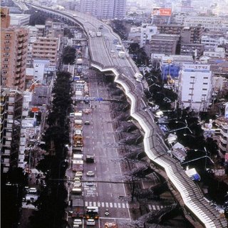
In the case of the elevated Hanshin Expressway - which links Kobe, Osaka and
beyond - huge single hammerhead reinforced concrete piers, that were holding
up the girders, broke off at their bases failing in shear and / or bending resulting
in a 500 m segment being tipped onto the ground (see Fig.6). This elevated
7
segment was constructed in 1968-1969 under older seismic provisions and
scheduled for retrofitting in the future by the Hanshin Expressway Public
Corporation (HEPC). Also, at this location of the elevated expressway, the
superstructure changed from steel to concrete increasing the mass of the
structure, and hence the earthquake forces acting on it, sufficiently to push this
section over and cause to collapse transversely. Lack of enough transverse
reinforcement was also observed in some of the collapsed columns.
Rail facilities were particularly hard hit in this earthquake. Three main lines; JR
West, Hankyu, and Hanshin that run in general on elevated embankment all
sustained embankment failures, overpass collapses, distorted rails and other
severe damage. In Kobe, the Shinkansen (Bullet Train) runs generally in a tunnel
through Rokko Mountain. At the east portal of the tunnel, the line is carried on an
elevated viaduct, built in the 1960’s. For a length of three kilometres, this viaduct
was severely damaged with a number of the longer spans collapsing due to shear
failure of the supporting columns.
Electric power and telecommunications performed relatively well in the
earthquake with little damage and reduction in service. Gas and water supply,
however, were not restored fully until around the middle of March. In spite of the
sincere efforts that both Kobe Water Department (KWD) and Osaka Gas
Company (OGC) made to implement anti-seismic measures to prevent such
service interruptions from occurring, 725,000 customers were without gas supply
and 29,000 were without water until around the middle of February. The water
and gas system sustained numerous breaks in their underground pipelines and
distribution systems with general lack of service in the cities of Kobe, Ashiya and
Nishinomiya.
8
6. LESSONS LEARNT
Tremendous damage was observed in this earthquake, some of which has not
been encountered in past earthquakes. The following important lessons were
recognised [Esper and Tachibana, 1995]:
a) Local site conditions had a major impact on the level of shaking. It is,
therefore, vital to identify the influence of subsurface soil conditions on the
amplification of ground motion.
b) Amplification of vibration due to topographic irregularities or / and the
presence of soft soil underlying this area was a major factor in increasing
the scale of damage to building structures and infrastructure.
c) Reinforced geotextile walls along the JR railway line in Higashi-Nada
district performed relatively well compared to the level of damage to the
surrounding site.
d) The failure of the Daikai station of the Kobe Rapid Transit Railway (KRTR)
is highly significant because it is the first instance of severe earthquake
damage to a modern tunnel for reasons other than fault displacement and
instability near the portal.
e) The peak vertical ground acceleration was approximately equal to the
peak horizontal acceleration, as recorded in some stations (e.g. MTRC).
This is much higher than what was observed in past earthquakes.
f) Matsumuragumi Technical Research Centre (MTRC) and Computer
Centre of Ministry of Post and Communications (CCMPC) are the only two
buildings in the affected area (approximately 35 km from the epicentre)
that are founded on base-isolators. The former was visited by the author
9
and no signs of damage exist at all throughout the whole building. The
same was reported by others on CCMPC building.
g) While hospitals are intended to provide relief to disaster victims, the NHK
television news reports [NCE, 1994] showed victims being carried away
from a damaged hospital after the earthquake. This type of structures
must be designed with greater resistance than ordinary structures.
h) Most failures in reinforced mid-rise buildings that were constructed during
the 1960’s and 1970’s appear to have been shear failures of columns that
had very light transverse reinforcement and / or unwelded stirrups. This
indicated bad supervision of works at the time of construction which was
supported by other examples such as; some fillet-welds that were
encountered during investigation works on some buildings were found to
be specified as butt-welds on design plans.
i) A report in 1990 presented to the Hanshin Expressway Corporation (HEC)
showed that, chemical deterioration inside the concrete pillars has been
taking place for some time due to what is known as alkali-aggregate
reaction causing the pillars to crack [NCEER, 1995]. Although this was
acted on immediately with regular maintenance schemes involving the
injection of a special resin into the cracks to stop deterioration, it was
reported, after the earthquake that the strength of the pillars immediately
before the earthquake were only around 42% of their original strength.
7. CONCLUSIONS AND RECOMMENDATIONS
It has to be made clear that Kobe’s destruction was not a failure of Japanese
technology. Evidence was shown, that the majority of the buildings designed
according to the present Japanese codes sustained little or no damage [EEFIT,
1998]. The fact of the matter is not only, however, investigating which buildings
10
performed well and what code they satisfied. Each earthquake is unique. What
really matters is what engineers and decision makers, such as politicians, should
learn from this recent disaster so that future hazards can be made less damaging.
The following recommendations are made:
a) There is an urgent need to establish reliable and cost-effective techniques
to evaluate, repair, strengthen / retrofit existing structures and buildings in
Japan (and in affected countries in the future) that suffered minor or
localised damage. This particularly applies to structures, buildings and old
wooden houses, elsewhere in Japan, that were constructed before current
seismic design regulations were implemented.
b) A global evaluation of seismic performance of buildings must be used to
evaluate the effectiveness of design codes, in all countries that are at
seismic risk.
c) Current Japanese seismic codes do not consider importance factors, as
the design and construction of Kobe port facilities indicated. A review of
these codes is now considered necessary.
d) Higher values of peak vertical acceleration was experienced in this
earthquake. This was also suggested by certain types of damage
observed in various structures. Hence, a review of all design codes of
practice is needed in order to take this factor into account.
e) Soil-foundation-structure interaction study should not be restricted to
heavy or special structures, such as nuclear power stations. Evidence
was provided by this earthquake that this interaction was significant in the
seismic behaviour of different types and sizes of structures.
f) Structures that are required to provide essential services after disasters,
such as hospitals and fire stations, must be designed with greater
11
resistance to seismic forces than ordinary structures. In this respect,
methods such as base-isolation [Esper et al, 2004], should be taken more
seriously as a powerful means for enhancing the seismic performance of
these structures.
g) Based on the Californian Northridge earthquake damage [Ref.8] and on
the author’s experience with bomb damaged buildings [Esper and Keane,
2004] in the City of London, hidden (undetected damage) would have
resulted following this earthquake, particularly in steel and SRC buildings.
A need to establish consistent methods for estimating the extent of
damage and the residual strength of these / similar structures is essential
in order to determine if these structures have the capacity to withstand
future earthquakes.
h) Construction on fill material needs to be re-examined along with the
phenomena of soil liquefaction. Reliable methods and techniques should
be used to control settlements of structures founded on fill materials.
i) Pancake collapse, or soft storey collapse, in building structures was mainly
due to using SRC for the lower storeys and RC for the upper storeys. This
formed a discontinuity in construction material and column sizes at the
level of transition, forming a brittle weak region in the building. Research
is needed to quantify the damage exhibited by these structures using
proper dynamic response analyses with models representative of these
damaged structures. The results of this study, then, should be fed back to
the seismic design codes of practice.
j) Good supervision and maintenance are two important factors that should
be maintained during the construction stage and throughout the intended
life of the structure. This will ensure that the seismic resistance of the
structure is not impaired from, at least, what it was designed to be.
12
REFERENCES
Architectural Institute of Japan (AIJ), Preliminary Reconnaissance Report of
the 1995 Hyogoken-Nanbu Earthquake, Edited by: M. Nakashima and M.
Bruneau, DPRI, Kyoto University, Kyoto, 1995.
National Centre for Earthquake Engineering Research, NCEER Response,
January 1995 special issue, State University of New York at Buffalo, New York,
1995.
New Civil Engineer (NCE), 29th September 1994 edition, UK.
13
Table (1): Damage Statistics in Hyogo, Osaka and Kyoto Prefectures:
Impact on
Residents
Damage to Houses
Deaths
Missing
Due to Ground Shaking
Due to fire
Collapse
Sever
e
Minor
Destr
oyed
Damaged
Hyogo
Prefecture
5394
2
81,206
62,82
6
7,119
337
Kobe city
54,949
31,78
3
7,046
331
Nishinomiya
17,716
13,47
4
48
4
Ashiya
2,543
1,519
13
2
Takarazuka
1,339
3,718
2
Awaji
73
583
Osaka
Prefecture
18
881
5,190
32,61
7
Osaka city
12
190
1,785
8,759
Toyonaka
4
654
2,842
Kyoto
Prefecture
1
3
3
1,109
Kyoto city
1
500
14
Table (2): Performance of Buildings Constructed by Ohbayashi Corporation:
Green Tags
(Negligible
damage)
Yellow Tags
(Moderate
Damage)
Red Tags
(Severe Damage)
Pre-1971 Old
Seismic Design
Code
42 %
22 %
36 %
1972-1980
Transitional
Period
72 %
17 %
11 %
Post-1981
New Seismic
Design Code
84 %
10 %
6 %
15
Fig. 1: Map of the affected area - Kobe and vicinity. (P: Port Island, R: Rokko
Island).
16
Fig. 2: Main shock epicenter, active faults and aftershock zone. (Source: DPRI,
Kyoto University).
17
Fig. 3: Collapse of timber houses.
18
Fig. 4: Collapse of a reinforced concrete column – inadequate transverse
reinforcement.
19
Fig.5: Pancake (or soft-storey) collapse of the sixth floor of the Kobe City Hall.
20
Fig.6: The collapse of the Elevated Hanshin Expressway.
21
Fig.7: Base – isolation system.


